CEDAR KEY, Fla. (AP) — Follow live updates about Hurricane Idalia, which has made landfall in Florida as a dangerous Category 3 storm, unleashing life-threatening storm surges and rainfall.What to know
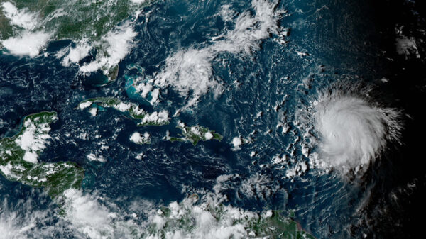
— Feeding on some of the hottest water on the planet, Hurricane Idalia is rapidly strengthening as it bears down on Florida
— A rare blue supermoon could play a role in an unfolding disaster as Hurricane Idalia takes aim at Florida’s west coast
— Florida’s Big Bend is one of the last truly natural places in the state. Now it’s in the bull’s-eye of a major hurricaneHurricane Idalia knocks out power
Hurricane Idalia was knocking out power in Florida after making landfall Wednesday morning. Over 200,000 customers were without power early Wednesday in the state, according to PowerOutage.us, which tracks outages nationwide. The vast majority of outages were in the state’s Big Bend region, where Idalia made landfall. Outages were expected to grow throughout the day in Florida, as well as Georgia and South Carolina.
At 8 a.m., Idalia’s eye was just inland from the coast, about 10 miles (20 kilometers) south-southeast of Perry, with top winds of 120 mph (195 kph) and moving north-northeast at about 18 mph (30 kmh).Hurricane Idalia makes landfall in Florida as a Category 3 storm
Hurricane Idalia made landfall on Florida’s west coast as a dangerous Category 3 storm on Wednesday, unleashing life-threatening storm surges and rainfall.
Idalia came ashore in the lightly populated Big Bend region, where the Florida Panhandle curves into the peninsula. The result could be a big blow to a state still dealing with lingering damage from last year’s Hurricane Ian.
The National Weather Service in Tallahassee called Idalia “an unprecedented event” since no major hurricanes on record have ever passed through the bay abutting the Big Bend.DeSantis urges those in Hurricane Idalia’s path to hunker down until it passes
Florida Gov. Ron DeSantis warned people in the path of Hurricane Idalia to “just hunker down until it gets past you.”
The National Hurricane Center expects storm surge to reach up to 16 feet (5 meters) in some areas of the Big Bend region, DeSantis said Wednesday at a news conference. Northeast Florida already had 11 tornado warnings and there were more possible, he said.
At 7 a.m. EDT Wednesday, Idalia was about 55 miles (90 kilometers) west of Cedar Key and 65 miles (105 kilometers) south of Tallahassee, the National Hurricane Center said. It was moving north at 18 mph (30 kph).
The U.S. Coast Guard is on standby and has pre-positioned 15 aircraft and more than 25 cutters and 20 flood response teams that are prepared to respond in the wake of the storm, Rear Admiral Douglas Schofield said. Crews flew over the western Florida area up to the Big Bend area and made call-outs to mariners to seek shelter. They’re ready to launch aircraft for urgent maritime search and rescue in the Tampa and Big Bend areas as the storm passes, he said.Hurricane Idalia closes in on Florida as Category 4 storm
Hurricane Idalia strengthened to a dangerous Category 4 storm Wednesday morning as it steamed toward Florida’s Big Bend region and threatened to unleash life-threatening storm surges and rainfall.
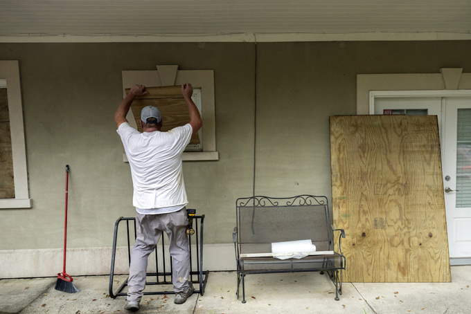
Florida residents living in vulnerable coastal areas were ordered to pack up and leave as Hurricane Idalia gained strength in the warm waters of the Gulf of Mexico, and authorities warned of a “catastrophic storm surge and destructive winds” when the storm moves ashore later Wednesday morning.
Idalia was projected to come ashore as a Category 4 storm with sustained winds of at least 130 mph (200 kph) in the lightly populated Big Bend region, where the Florida Panhandle curves into the peninsula. The result could be a big blow to a state still dealing with lingering damage from last year’s Hurricane Ian. It had grown into a Category 2 system on Tuesday afternoon and became a Category 3 just hours earlier Wednesday.
Copyright 2021 Associated Press. All rights reserved.


